TRIMBLE EARTHWORKS FOR EXCAVATORS

INTRODUCING UNDERTIME

The first aftermarket semi-automatic bucket and boom control system designed to transform job site performance. By automating precise bucket and boom movements, it improves accuracy, speeds up workflows, and reduces costly rework. Contractors gain a competitive edge by increasing efficiency, finishing projects faster, and staying on budget.

Trimble Earthworks for Excavators

NOW AVAILABLE ON SUBSCRIPTION WITH TRIMBLE WORKS!

Trimble Works

AUGMENTED REALITY

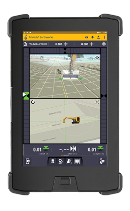
Trimble Earthworks for Excavators features advanced Augmented Reality, allowing operators to view 3D models at true-to-life scale within real jobsite surroundings. This technology simplifies complex designs, enhances safety, and helps crews work faster and more efficiently by blending digital models with the real environment.

TILTROTATORS SUPPORT

Trimble Earthworks integrates seamlessly with tiltrotators from engcon®, Rototilt®, and Steelwrist®. The system automates boom, bucket, and tilt angle control, while the operator manages stick and rotation functions. This improves accuracy, productivity, and versatility in excavation projects.

PAYLOAD MANAGEMENT INTEGRATION

With optional payload management, Trimble Earthworks combines grade control and payload data on a single screen. This integration boosts mass haul efficiency by preventing underloading, reducing overloading risks, and improving safety. Operators can also track productivity with Bluetooth® printing and web-based reporting tools.

VARIOUS CONFIGURATIONS

ACCORDING TO YOUR NEEDS

2D CONFIGURATION FOR HEIGHT AND SLOPE – Flexible starter solution for excavation, canal and trench construction, grading and profile work–the start of productivity.

3D SINGLE OR DUAL GNSS OR UTS CONFIGURATION – Powerful 3D control system to measure the exact position of the bucket for more complex grading and excavation tasks.

AUTOMATIC GUIDANCE – Available for a broad range of machine brands and models, the automatic system controls the hydraulics of the machine and achieves high precision in flat or inclined surfaces. With the benefits of automatic functionality, increase the productivity of your machine up to 40%.

How it works:
1. The excavator is placed in auto mode.
2. The operator controls the stick.
3. Trimble Earthworks controls the boom and bucket.
4. Stay on grade, reduce overcut and increase production.

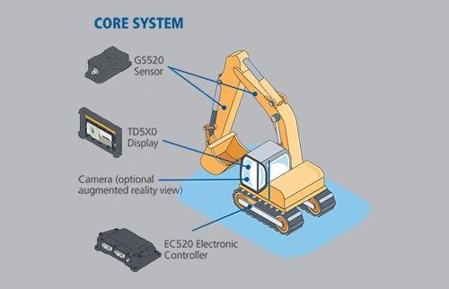
CORE SYSTEM

The Core System from Trimble for excavators is the fundamental starting point for an effective solution for your excavator and project needs.

    • GS520 Sensor
    • TD5X0 Display
    • Camera (optional augmented reality view)
    • EC520 Electronica Controller
Core System
Automatics System

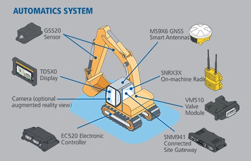
AUTOMATICS SYSTEM

A comprehensive solution for implementing Trimble Earthworks for your excavator for streamlined and accurate projects.

    • GS520 Sensor
    • TD5X0 Display
    • Camera (optional augmented reality view)
    • EC520 Electronica Controller
    • MX9X6 GNSS Smart Antennas
    • SNRX3X On-machine Radio
    • VM510 Valve Module
    • SNM941 Connected Site Gateway

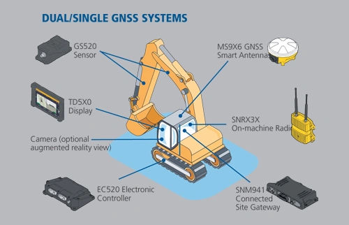
DUAL/SINGLE GNSS SYSTEMS

Comprehensive solution for excavators so your project can finish on-time and on-budget.

    • GS520 Sensor
    • TD5X0 Display
    • Camera (optional augmented reality view)
    • EC520 Electronica Controller
    • MX9X6 GNSS Smart Antennas
    • SNRX3X On-machine Radio
    • SNM941 Connected Site Gateway
Dual/Single GNSS Systems
Universal Total Station System

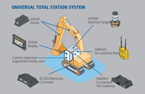
UNIVERSAL TOTAL STATION SYSTEM

Top field technologies for Trimble Earthworks for Excavators with the highest level of accuracy.

    • GS520 Sensor
    • TD5X0 Display
    • Camera (optional augmented reality view)
    • EC520 Electronica Controller
    • MT900 Machine Target
    • SNRX3X On-machine Radio
    • SNM941 Connected Site Gateway

CONFIGURATION OPTIONS FOR EXCAVATORS

Product ApplicationsConfigurationsDescription
3D Machine Control – Highway Construction – Mass Excavation – Land reclamation – Dam and reservoir construction – New infrastructure projects – Landfills and waste depositsSingle GNSSMeasures the position of the bucket and compares that to design data for rough grading and mass excavation on complex design surfaces
Dual GNSSMeasures the exact position and heading of the bucket for rough grading and mass excavation on steep slopes and complex design surfaces
Universal Total Station (UTS)Total station based system for extreme accuracy for lift and layer control, material monitoring, or where GNSS is not the ideal solution because of overhead obstructions
2D Machine Control – Residential and commercial sites – Road construction – Trenches – Ditches – Finished slope work – Dredging and waterways – Digging footers and basementsDepth, Slope and Elevation ControlHighly flexible system for excavation, trenching, grading and profile work
Depth and Slope with Bench ReferenceSimply enter the desired depth and slope, or bench using your bucket. The system will provide guidance to a depth or slope based on distance from a known point or “bench” on the ground.
Laser ReferenceA rotating grade laser provides a reference plane across the job site.
Laser Reference with HeadingThe excavator can be rotated without the need to re-enter the desired depth and slope to maintain consistent accuracy.
Depth and Slope with GNSSKeep the easy to use Depth and Slope or Bench and Go workflows, and leverage GNSS to move around the site without having to use touch points or laser reference to carry your elevation. Rotate and maintain constant slopes as the GNSS also provides heading.

Reach out & lets talk!

Fill out the form below and we’ll be in contact, or reach out directly on 0800 4748 324